
The Northland Region (Maori: Te Tai Tokerau) is the northernmost of New Zealand’s 16 local government regions. Northland is often called the Winterless North due to its subtropical climate. Local New Zealander’s also refer to it as the Far North. This can sometimes confuse tourists who do not release that its all the same area.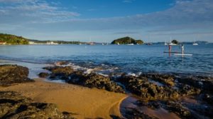
Northland is a fairly large area, the town with the most population in the area is Whangerei but it is not the largest town in regards to actual size. The largest town is Keri Keri.
Due to its latitude and low elevation, Northland has the country’s highest average annual temperature. However, as with other parts of New Zealand, climate conditions are variable. In summer, temperatures range from 22 °C to 26 °C, occasionally rising above 30 °C. In winter, maximum temperatures vary between 14 °C and 20 °C. 
Typical annual rainfall for the region is 1500–2000 mm but varies at different altitudes. Northland has an average of 2000 sunshine hours annually. Winds are predominantly from the southwest. Occasionally in summer, the region experiences stormy conditions from former cyclones which generally become much weaker once they leave tropical latitudes.
As with most places in New Zealand, it is essential to make sure you have clothing for any situation, especially rain.
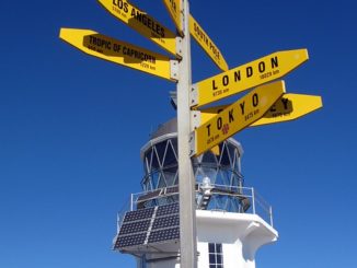
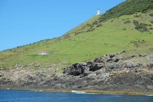
Cape Reinga
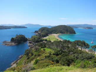
Lashed by winds, pounded by surf and sand or soothed by the calm of sunlit days, this remote, far northern extent of New Zealand has a wild and unpredictable nature. Around its shores sweep the currents of the Tasman Sea and the Pa cific Ocean which meet in a foaming well of broken water over the Columbia Bank, just west of the Cape. Its lighthouse is one of New Zealand’s iconic landmarks. The beam once shone from Motuopao Island where it had been installed in 1879, but was not visible from the water of North Cape so in 1941 a lighthouse was built at Cape Reinga using the original lens from Motuopao. The remains of the original tower are still seen on the northern end of the offshore island. An automatic battery-operated unit now stands on Cape Maria van Diemen and the Cape Reinga light today is electric. It was automated in 1987 and is now managed by computer from Wellington. The 1000-watt light bulb magnified by the lens system throws a signal of warning 49 km out to sea and is often the first light in New Zealand that sailors see.
The whole of the northern tip of the North Island is steeped in Mäori heritage. 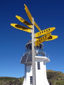 It is the most spiritually significant part of New Zealand for it is here that after death, all Mäori spirits travel up the coast and over the wind-swept vista to the pohutukawa tree on the headland of Te Rerenga Wairua. They descend into the underworld (reinga) by sliding down a root to fall into the sea below. The spirits then travel underwater to the Three Kings Islands where they climb out onto Ohaua, the highest point of the islands and bid their last farewell before returning to the land of their ancestors, Hawaiiki-A-Nui. Many a tourist gazing at the spectacular view has felt the wind alternately buffet and slide over them. It has
whispered past their ears, raising the flesh on their arms as it rolls over the headland. Was it merely the
wind or another soul saying goodbyes as it begins the long journey home? The area from the car park down to the lighthouse has immense spirituality which Europeans may liken to that within the walls of great cathedrals such as Notre Dame or St Pauls. In recognition of this and as a mark of respect visitors are asked to refrain from eating or drinking here.
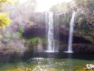
Rainbow Falls Walk
From Kerikeri township, head north-east to the Heritage Bypass, then turn left into Waipapa Road. Rainbow Falls Road is on the left off Waipapa Road. Access to the Rainbow Falls is from the parking area at the end of Rainbow Falls Road or from the Kerikeri River Track itself.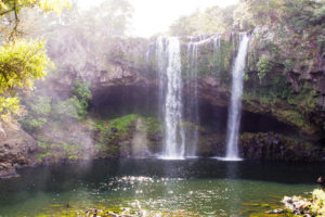
Three stunning viewing platforms are at the top of the Rainbow Falls. The Te Araroa Trail joins the Kerikeri River Track at this point and carries on down the hill towards the Kerikeri Basin. You can stroll along the riverbank to the spectacular Rainbow Falls, where the water tumbles into a popular swimming hole surrounded by native bush. The falls are also a popular destination for kayakers to explore. There are parking and picnicking areas at the end of Rainbow Falls Road.
Kayaking in Northland New Zealand and Bay of Islands
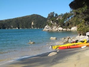
Kayaking is a fun way to explore the coastal areas of Northland New Zealand. You may think that it would be too expensive to do this but you may find that your accomodation (motel, hostel, campground) could have some kayaks you can use for free or relatively cheaply.
Why not take some fishing gear out, even a couple of hand lines and try for some of the abundant fish that are in this area. You may land yourself some fish for dinner!
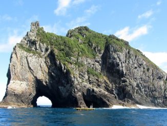
Cape Brett Track
Cape Brett Track traverses through native and regenerating bush. The track runs along the ridge through Maori-owned land before reaching conservation land at Deep Water Cove – Manawahuna for the last 6 km of the track. You can take a side-track (1 hr return) down to Deep Water Cove, where you can enjoy a refreshing swim and snorkel.
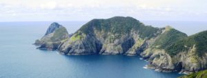
From the forested ridges, you can take in spectacular coastal scenery. Towards the Cape, walking alongside the dramatic cliff-face, you can see abundant fish and bird life below – often dolphins and seals will come close to shore.
From Deep Water Cove onwards, the track gets more challenging and becomes quite exposed with steep drop-offs to the sea below.
Although it is not that far to the lighthouse, it will take you about 2-3 hours, and can be quite tiring. The effort is rewarded with outstanding views of the outer Bay of Islands, north to the Cavalli Islands and south to Whangaruru and beyond to the Poor Knights Islands.
Along the track, you will come across an electric fence crossing the width of the peninsula. This was constructed in 1995 to reduce the impact of possums on the coastal bush. Ensure the gate is closed.
The track begins from Oke Bay in Rawhiti, or can be joined from the Whangamumu Track. Access is also available from the landing at Deep Water Cove.
Cape Brett is 30 km north east of Russell. You can get to Cape Brett and Whangamumu via Rawhiti Road.
From Russell, take the Russell-Whakapara Road for 13.8 km and turning off at Kempthorne Road. Follow the road through Parekura Bay, continuing on to Manawaora Road. At the top of the road, turn left onto Rawhiti Road.
From Whangarei travel north turning off SH1 at Whakapara. Follow the Russell Road until you get to Rawhiti Road.
To access Cape Brett Reserve by sea, land at either Deep Water Cove or at Cape Brett. A water taxi is available from Russell and Paihia.
Fees
All trampers must pay a track maintenance fee for crossing private land between Rawhiti and Deep Water Cove:
Adult: $40
Child: $20
Track and hut fees can be paid at the Bay of Islands i-SITE Visitor Centre (external site) in Paihia.
There is no charge for the section of track between Deep Water Cove and Cape Brett, or Whangamumu to Te Toroa Bay.
Know before you go
No camping or fires.
Pack out all your rubbish including food scraps, to prevent rat infestations.
Parking at 253 Rawhiti Road (Julie Witehira), Kaingahoa is recommended. Secure parking is also available at Hartwells, Kaimarama Bay, end of Rawhiti Road, for a small fee.
Safety – To walk this 16 km undulating track, you need to:
be self-sufficient and have have a high degree of fitness and experience
take extreme caution as there are many bluffs and steep cliffs
remain on the track at all times
have 8 hours of daylight one way to complete the journey to the old lighthouse settlement
wear tramping/hiking boots, especially if the track is wet
take plenty of water to drink during the tramp
carry a water treatment system if you are staying at the Cape Brett hut as the quality of drinking water cannot be guaranteed during summer
Before tramping in or staying at the hut, check with the DOC Bay of Islands office about the water supply.
(info sourced from Dept of Conservation)